
I have run across "The Enthusiast" an advertisement, several times on the web. Someone has taken the idea of the Sky Gypsies and reformatted it for their own purposes. In this case an advertisement for E TRADE. When the creation of an idea and it's implementation focuses solely on people and not the concept it is subject to vagaries of human nature and the probability of success diminishes. But when the concept itself is promoted in new and different ways, the probability of success increases. That is not to say promoting people is not important, but people should come second to the concept. A concept can be manipulated and formed into what ever shape works best in the effort to get the message across. Trying to promote an idea by focusing on the people involved results in misunderstandings, and that will not be as successful.
So keep it about the concept, in this case weight shift control aircraft, flex wing microlights, and ultralight trikes and not the people involved. The idea will grow and spread with others adding to the concept as they find a role in the promotion of the idea.
Friday
Wednesday
Aerotrekking code

Based on the generic explorer’s code that is reiterated by many conservation groups with slight variations, the code of the Aerotrekker is applicable to all who fly weight shift control aircraft, using them as tools to explore the world around them.
Take nothing but pictures
Leave nothing not even footprints
Break nothing but silence
Kill nothing but time
The original code is attributed to various sources including Chief Seattle in 1854 and other references go back even earlier. But whatever the original source, the Aerotrekkers code aptly describes the unique way weight shift control light sport pilots are able to explore the world.
Tuesday
Weight shift aircraft in the big time
Tango Hotel, the Air Creation Tanarg that was the subject of a 55 image photosynth is currently being featured on Microsoft's Photosynth site. Have a look and take a virtual tour of Air Creation's flagship weight shift control light sport aircraft.

The photosynth may also be found here or here in the most viewed catagory.

The photosynth may also be found here or here in the most viewed catagory.
Sunday
The Big Synth from Microsoft
The initial experiments with Microsoft's Photosynth are very promising. It appears possible to reproduce the "Big View" that weight shift control aircraft pilots have while flying. There are now 6 synths ranging from 10 to 74 images now posted at the Photosynth site. The largest is the 74 aerial photographic 3D panorama of the east flank of the Chiricahua Mountains. Taken during a series of the PTS steep bank turn maneuvers flown along the east flank of the mountain range this panorama allows the viewer to see the mountains as we see them. The software seems to run slow on this site so I would suggest viewing the synths at Microsoft's Photosynth site.
It should be possible to use the aircraft as a paint brush to paint an image with aerial photographs. If the site and flight paths were preplanned this would create 2 images, 1 the aerial panorama itself, and 2 embedded within that another form or shape visible only in the point cloud. We will see.....
It should be possible to use the aircraft as a paint brush to paint an image with aerial photographs. If the site and flight paths were preplanned this would create 2 images, 1 the aerial panorama itself, and 2 embedded within that another form or shape visible only in the point cloud. We will see.....
Thursday
Photosynth aerial panoramic photographs, a 3D interactive experience
Translating the excitement of the aerial view from an open cock pit weight shift control light sport aircraft for others to enjoy is one of the goals here at the Sky Gypsies and from the quality and unique aerial photographs many other pilots share this vision. But creating the "Big View" photographs or PTS based panoramas (PTSPs) takes a good deal of hard work, in planning, flying, and processing. Well, there is another method that can be used to create engaging and interesting aerial panoramas without all the precision flying and processing. Microsoft has a really neat application called photosynth. It represents a different way of "seeing" and "[i]n simple terms, Photosynth allows you to take a bunch of photos of the same scene or object and automagically stitch them all together into one big interactive 3D viewing experience that you can share with anyone on the web." This is an ideal application for aerial panoramas and creating interactive flying experiences with a still camera. I have created several examples using both horizontal panorama photographs and vertical panoramas, 2 of which are presented below. (1) is a group of 17 aerial photographs of the Chiricahua Mountains, a subset of which were used to create the aerial panorama presented on Monday. While the second photosynth is of a rock outcropping east of Amigos del Cielo at the base of the Peloncillo Mountains. It should be possible to create a complete 3D view of this rock outcrop by flying and photographing it from all directions and then photosynthing the scene. Here is a link to the how to video.
Before you can view the photosynths you will be prompted to download Silverlight from Microsoft. It will download for you and just reload the page.
(1). 17 horizontal photos of the Chiricahua Mountains centered on Sulfur Canyon. 100% synthy
(2). 10 vertical photos of “The Rock” a low level fly over of a rockoutcrop. 89% synthy
Wednesday
Who is a Sky Gypsy?
Some people seem terribly interested in who the Sky Gypsies are, so here are 2 videos showing the difference.
Not a Sky Gypsy
This is a Sky Gypsy
You have to be able to bear it all to be a Sky Gypsy, and yea, you have to know how to fly weight shift control light sport aircraft.
Not a Sky Gypsy
This is a Sky Gypsy
You have to be able to bear it all to be a Sky Gypsy, and yea, you have to know how to fly weight shift control light sport aircraft.
Monday
Low level Aerial Panorama of Sulfur Canyon and the Chiricahua Mountains
Centered on Sulfur Canyon on the east side of the Chiricahua Mountains this panorama photograph is composed of 10 images. Taken from just above a small double hill which sits at the mouth of Sulfur Canyon (31 50' 49.35" N, 109 06' 45.66" W) and 1 mile from the cliff face, the image stretches from just south of Cave Creek Canyon on the right side of the image (north), south along the mountain range to Squaw Mountain just north of the entrance to Price Canyon, a distance of approximately 16 miles. One of the double hill hilltops is visible in the foreground at the bottom center of the low level aerial photograph giving the impression of a ground based panoramic photograph. The "steep bank turn" practical test standards maneuver was used to set the aircraft's flight path and capture the 10 consecutive images.

Click here to open a larger version of the image alone on a black background.
Click here to open a larger version of the image alone on a black background.
Saturday
Not the Cover of the Rolling Stone or The Tryst comes to the Sky Gypsies Complex


Last night the band Tryst made their first stop on a southern US summer tour. The 3 band members played to the early morning hours under clear skies at the Sky Gypsy complex to kick off the tour. Here is The Tryst's My Space page, head on over and listen to some of their tunes.
Friday
Aerial Panorama Photographs: The Utility of the Practical Test Standard Maneuvers
I frequently hear complaints about the PTS maneuvers and it generally follows this path. Why do I have to learn these, what good are they? This is stupid, it doesn’t show that I can fly. I can do these with my eyes shut. Why can’t I go below 400’, it doesn’t matter. What do you mean, pink slip? But demonstrating precise control of the aircraft to the designated pilot examiner is one of the tools the FAA uses to ensure we are competent to fly. I have used one of the PTS maneuvers, the steep banked turn, to demonstrate why precise control is a good thing to know. One of my goals has been to translate what I see and feel when flying into pictures, videos, and words that others can relate to, to generate the desire in others to fly weight shift control aircraft. My recent experiments have centered on panoramic photographs. Now flying around in circles sounds simple but in reality to generate a panoramic photograph requires multi-tasking since both aircraft control and stable photography take place at the same time. If aircraft control consisted of flailing around the sky in some sort of circular path with changing altitudes then the photography would be impossible. A precise flight path and altitude control of the 45 degree steep bank turn is required to allow the capture of uniformly centered photographs required for the panoramic composite.
Here are 2 examples of panoramas made at the hard deck for ground reference maneuvers (400’), yes, I know 1000’ is the hard deck for performance maneuvers so I get a pink slip for flying a performance maneuver at a ground reference maneuver altitude. One panorama is looking south and one is centered on the northeast. Both were taken from the intersection of Highway 9 and 80 in the San Simon Valley just before an afternoon monsoon blew in. I was able to take the 10 or so photographs in each panorama only by precisely controlling the aircraft in the steep bank turn. So, if for no other reason than to gain the ability to make good panoramic photographs I would suggest practicing the steep bank turn, and if your in student mode here is a useful reason to learn the maneuver precisely.
I’m working on the complete 360 view but it requires a lot of computer memory and takes time to generate the panoramic images.

Looking south down the San Simon Valley, the Chiricahua Mountains on the right and the Pelocillo Mountains on the left.

Looking northest to the Peloncillo Mountains
Click photographs to enlarge and open in a new window.
Thursday
To much aerial photography not enough training information
I realize there has been a number of posts on low level and tilt shift aerial photography recently and very little on student training. I am in the process of remedying that and will have some new PTS posts soon.
Wednesday
An Alternative Proposal
Note: This is a personal opinion and is therefore written in the first person with a hat tip to Jonathan Swift.
I have noted in several posts that light sport aviation activities here always peak the interest of the Border Patrol and Homeland Security. There have been several crossings by smugglers using weight shift control aircraft and all those caught have been carrying bales of pot. Well, I suggest that a cost benefit analysis of smuggling bales of weed across the border would demonstrate that it is not a very cost effective proposition. A stripped down aircraft with a single pilot can only carry 3-400 lbs of pot. With a street value of $ 800-1000/lb (personal communication, Border Patrol agent) this would seem not to be cost effective compared with other commodities. Wouldn’t it be much more cost effective to carry something more valuable? There are a number of illegal drugs that have a higher street value but I would suggest something different. Instead of drug smuggling with it’s severe penalties for smugglers when caught, I would suggest something that can have a positive benefit to society, smuggling babies. Babies are in high demand, many infertile couples seek adoption both in and out of the US and in many cases the waits are long or the couples are unsuccessful . The costs associated with adoption can be upwards of $30,000 and in many cases only the very wealthy can afford the costs associated with the process.
The 50th percentile weight for a 6 month old baby boy is 18 lbs and a baby girl the weight is about 16 lbs. So lets say an average of 20 lbs./baby and an aircraft with a payload of 300-400 lbs. This translates to 15 to 20 babies/flight that could be brought instead of pot or other drug commodity. Like in the 1965 movie The Flight of the Phoenix, the babies could be placed on top of the wing where they would act a turbulators or alternatively outriggers off the carriage could be built so the babies could ride behind and to each side of the pilot.
At $30,000/baby the price/lb is $1500 almost doubling the price for illegal drugs. In addition, the positive benefit to society is clear - a steady supply of babies for infertile couples. Finally, the penalties for getting caught transporting babies across the border are less than a drug smuggling conviction. It seems to me that babies could be a much more lucrative venture than drugs.
Tuesday
Desert Waterfalls
The tailings from abandoned mines spill down the steeply sided Granite Gap Mountain like waterfalls. The mine entrances resemble springs that are the source of the dirt and rock creating each waterfall. This aerial tilt shift photograph was taken at an altitude to show both the entrances and tailings waterfall.

Desert Waterfalls. Click photograph to enlarge.

Desert Waterfalls. Click photograph to enlarge.
Monday
Self Portrait or How it is done
They are worse than automobile drivers on cell phones, pilots with cameras that is.
Caught this image of my reflection in the GPS while photographing a Trinchera in the southern San Simon Valley at the mouth of Skull Canyon and it captures the ingredients required to make low level aerial photographs. The minimum prerequisites are calm air and good light. Calm conditions make all the difference when flying in confined areas or at low altitudes and good light makes all the difference in creating an interesting photograph. Then the photographic target is flown at series of decreasing altitudes looking for potential problems and obstacles (canyon walls, the ground, small hills, and power lines), all the while rechecking the winds and figuring out the best line past the target. Especially important is a flight path where I will have enough room to turn around once finished running the camera. Once this is worked out, I pick a line along the photographic target and do a low pass towards the target and begin shooting. This is repeated several times until I have something acceptable or I abort and come back another day and try again. I have photographed some sites numerous times because something was not correct, generally the winds. The goal is to bring back interesting views of the landscape and other features and not to fly into the ground.
On this particular flight I had to deal with a canyon entrance and high rock walls with a rocky hill in my flight path past the target. So just after taking the photographs I had to climb and turn to fly over the hilltop shown below.
 Self portait

Skull Canyon entrance and rocky hill on the left, shown below in detail.
 Early high test pass over rocky hill obstacle.
Caught this image of my reflection in the GPS while photographing a Trinchera in the southern San Simon Valley at the mouth of Skull Canyon and it captures the ingredients required to make low level aerial photographs. The minimum prerequisites are calm air and good light. Calm conditions make all the difference when flying in confined areas or at low altitudes and good light makes all the difference in creating an interesting photograph. Then the photographic target is flown at series of decreasing altitudes looking for potential problems and obstacles (canyon walls, the ground, small hills, and power lines), all the while rechecking the winds and figuring out the best line past the target. Especially important is a flight path where I will have enough room to turn around once finished running the camera. Once this is worked out, I pick a line along the photographic target and do a low pass towards the target and begin shooting. This is repeated several times until I have something acceptable or I abort and come back another day and try again. I have photographed some sites numerous times because something was not correct, generally the winds. The goal is to bring back interesting views of the landscape and other features and not to fly into the ground.
On this particular flight I had to deal with a canyon entrance and high rock walls with a rocky hill in my flight path past the target. So just after taking the photographs I had to climb and turn to fly over the hilltop shown below.
 Self portait
Skull Canyon entrance and rocky hill on the left, shown below in detail.
 Early high test pass over rocky hill obstacle.
Friday
Desert drainages in Black and White
Here is a series of low level aerial photographs of erosion features and drainage patterns taken from an altitude of about 100' AGL from a weight shift control aircraft and treated to give the impression they are high altitude aerial photographs. They were also converted to black and white to highlight the contrast between the light and dark layers of soil. Compare the photographs below with these Space Shuttle images.


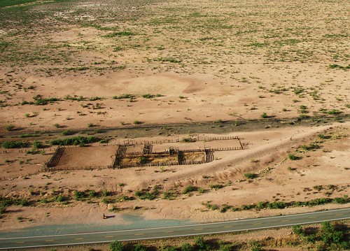
Pullman Railroad Cars in the San Simon Valley
Evidence of old El Paso and Southwestern railroad in the San Simon Valley is most visible in the railroad bed that parallels Highway 80 from Douglas to Antelope Pass, but there is additional evidence that is less visible but perhaps more important. The rail line to El Paso was an extension of the original line between the mines in Bisbee and the smelter in Douglas, used for hauling ore. The amount of activity on the line between Douglas and El Paso was reportedly minimal due to the low population density in southern New Mexico, but the photographic evidence shown below indicates that passenger service was available. Pullman cars were the standard in railroad accommodations and there are 2 examples in the San Simon Valley, the one shown below and another partial example sits at the mouth of Horseshoe canyon near the large stone spiral. For reference, compare the image below with this Pullman car museum example.

Click photograph to enlarge

Click photograph to enlarge
Thursday
Prehistoric Advertising
Advertising is all around us with people trying to sell everything under the sun using all sorts of tools to get the viewers attention. But tools and resources for advertising can be expensive. Here in the Sky Gypsies advertising department there are no tools or resources to promote weight shift control light sport aviation. Everything is created from scratch and there is a constant effort to create new ideas and methods to provide visitors with a diversity of interesting material supporting the notion that "what can be done on the ground is more fun in the air". But what about cultures from the past? How did they promote their ideas and products to one another? Has anything really changed or do people use the same advertising methods today that were used thousands of years ago?
Here are the results from a Google search of “advertising nested bowls“. A review images returned with this search term all show similar presentations all the products, essentially a set of nested stacked bowls. When this search is expanded to include images of cultural material from the past, the search term becomes “archaeology nested bowls” and returns these images.
Even partially uncovered it is obvious the pottery bowls were displayed stacked and nested. Nothing has changed in the presentation of bowls in thousands of years. While it can be argued this presentation style was driven by function rather than form the fact remains the same, the style of presentation has not changed.
To extend this idea the advertising department created a set of nesting bowls of it’s own using only rocks. No metal or electric tools were used to create these stone bowls. They are reproduced in the style of stone bowls found at sites around the southwest and presented in the same format that has been used for thousands of years one bowl in another. Hand pecked, created by banging one rock on another, the presentation style of these stone bowls is indicative that the same old advertising approaches don’t always work and new methods of presentation are required to get people’s attention.
 Stacked stone bowls in a metate.
 Nested stone bowls
If weight shift control light sport aviation is to move ahead in an increasingly competitive market and move beyond being a "novelty in a niche market" new advertising approaches that will attract peoples attention are required. I would suggest that banging rocks together in an attempt to create the same old advertising does not work.
Wednesday
From North to South
A while back 3 pilots flew down from northern New Mexico to check the place out, anything north of I-10 qualifies as the north to us since Amigos del Cielo airpark and the Sky Gypsies complex is in the bootheel of Mew Mexico close to the border with Mexico. Jeff Gilkey, Frank Dempsy, and Rick Cooper flew down from Double Eagle and Balen New Mexico for a couple of days visit and some flying. Jeff wrote up their adventures and the article was published in "Light Sport and Ultralight Flying" magazine last October. Jeff finally received the pdf of published article and it can be read here or on Jeff's Flight Log. There is also a link in the side bar under "Sky Gysies in the news".
Tuesday
Sky Gypsies Sculpture: Artists Across Time
There is a new slideshow in the sidebar under the heading “Sky Gypsies Sculpture, Artists Across Time”. It will showcase photographs of sculptures created in the Sky Gypsies Studios and hosted at Picasa. The artwork is inspired and created using recycled pottery sherds collected over the past 20 years. Some partial reconstructions of different vessels are used and some sculptures are free form. I detailed some of the background ideas in an earlier post introducing the sculptures. Look for more sculptures to appear as they are completed.

Plus and Minus. A Casas Grande partial reconstruction on a sherd base.

Plus and Minus. A Casas Grande partial reconstruction on a sherd base.
Sunday
Combining tilt shift processing with low level aerial photographic views of the desert
Flew back across the bootheel to Playas Valley this morning for some more photography. Below are several images of drainages in Playas Valley processed with tilt shift software. Most of the photographs were taken at an altitude between 50' and 100' AGL. This technique works quite well with low level images and is recommended it to anyone photographing the landscape.
Of course the Border Patrol was there as usual as backup.
Click image to enlarge

Inverted tilt shift modified desert drainage. Inverting the photograph gives the appearance the drainage's rise out of the desert floor.

Desert tilt shift

Draining the Desert
Of course the Border Patrol was there as usual as backup.
Click image to enlarge

Inverted tilt shift modified desert drainage. Inverting the photograph gives the appearance the drainage's rise out of the desert floor.

Desert tilt shift

Draining the Desert
Friday
Tilt shift low level aerial photography
Tilt shift photography is an optical technique requiring a special lens. The lens is moved relative to the plane of focus resulting in images where the center is in focus and the margins are out of focus. Similar effects can be created using a large aperture and a shallow depth of field. With the advent of digital cameras and computer processing a similar effect can be created by shoving 0s and 1s around. This method is used to create tilt-shift miniatures, resulting in life size objects appearing as miniatures. In many cases high angles are also used to help create the impression of looking down on a miniature. This makes this technique especially well suited to aerial photography. Since parts of the image are defocused the photographer can draw the viewers attention to specific parts of the photograph. An online tilt shift image processing resource where the photographer can manipulate their own photographs is TiltShift maker. Several images from the Flickr site have been electronically tilt shifted and are shown below and a slideshow of tilt shift images is in the side bar near the top of the page. As you will note from the image gallery, landscapes seem best suited to this technique.
 Original Aerotrekking aerial photograph
 Tilt shift modified Aerotrekking aerial photograph
click to enlarge
 Original photograph of Playas siding on the old El Paso and Southwestern railroad
 Tilt shift modified aerial photograph of Playas siding
click to enlarge
 Original Aerotrekking aerial photograph
 Tilt shift modified Aerotrekking aerial photograph
click to enlarge
 Original photograph of Playas siding on the old El Paso and Southwestern railroad
 Tilt shift modified aerial photograph of Playas siding
click to enlarge
Thursday
New Mexico’s Bootheel Photo Documentation Project
If you have looked at the San Simon Valley, where the Sky Gypsies are based, recently on Google Earth you will note that new photographs of the landscape have started appearing. By combining Aerotrekking in weight shift control aircraft with aerial photography as described in this post it is possible to create landscape photographs of this area of the country from a unique perspective not available to many.

Photo documenting the bootheel while Aerotrekking across New Mexico. Click to enlarge.
Besides the satellite imagery and traditional view down aerial photographic information collected by the USGS, there is little photographic information on this part of New Mexico which is one of the least visited areas of the state. Since the basin and range region is ideally suited to low level (Aerotrekking) aerial photography and with the initial success of the photography experiments expanding the project is natural.
The 1200 square miles that comprise the bootheel lies in Hidaglo county New Mexico and is part of the almost 30,000 square miles of the Gadsden Purchase of 1854. While the bootheel proper is in Hiladgo county New Mexico and covers only a small part of the Gadsden Purchase, the expanded project includes photographs from some areas outside of the bootheel (south of I-10) but still lies within the area covered by the Gadsden Purchase. The photographic collections of the bootheel may be found here with additional photographs here. The current status of the project may be seen on this map or follow the project on Google Earth and watch as more photographs appear over time.

Entrance to Horseshoe Canyon seen while Aerotrekking in the San Simon Valley on the east flank of the Chiricahua Mountains. Click to enlarge.
Subscribe to:
Posts (Atom)


