 |
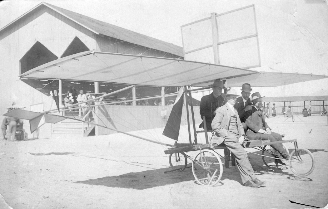
| A Pearse monoplane in Douglas AZ. Photo from the Morrow Family website |
Showing posts with label aviation history. Show all posts
Showing posts with label aviation history. Show all posts
Wednesday
A little more Aviation History from this corner of the Desert
The history of aviation in this little corner of the desert southwest is truly amazing. From the early Rodeo Intermediate Airfield to more modern uses of aircraft in the valley aviation has influenced the area since its' inception. I recently came across this image taken at the Douglas Fairgrounds, circa 1910, of an early monoplane constructed locally. Probably built by the Douglas flying club it shows several men including W. K. Morrow (in the bowler hat) whose family ranched in the Chiricahuas for many years. Just reinforces the notion that aviation still has a place here.
Rodeo Intermediate Field, the First Airport in the San Simon Valley
Note: This first appeared in Blogging from the Boot Heel
An ongoing project for the past several years was the documentation and submission of the Rodeo Intermediate Field as a site worthy of a New Mexico historical marker. It began with the discovery of the site while flying one afternoon several years ago. Long straight lines in the desert and a big red arrow pointing east toward El Paso stood out on the desert at the mouth of Antelope pass along Highway 9. Exploring further on foot, building foundations and runways became apparent. Inquiries to local residents produced no concrete information and many were unaware of the sites existence. Information about the site required a longer memory and after consulting author and the local historian Jr. Gomez and explanation arrived, an old airport. The local memories only went back to WWII when the site was an Army Air Force Auxiliary field with lighted runways visible in Portal, but further research turned up a longer history which extended back to the late 1920's. Developed by the Department of Commerce and known for a year as the Pratt Intermediate Field, the name was changed to the Rodeo Intermediate Field. The site was developed in support of early commercial aviation along a route from California east. Early commercial aviation, both transport and mail relied on the iron compass as a navigational aid and the El Paso and Southwestern Railroad running from Douglas to El Paso was an ideal navigational aid along a southern route. Other intermediate field routes were established across the U.S. and in New Mexico an early route also extended across the northern part of the state through Albuquerque.
Standard Airlines, a subsidiary of Aero Corp and later to become TWA, began flights from California to El Paso on Feburary 5, 1929 as an Air-Rail line where passengers would fly part of the route then continue by train east from El Paso. In support of this commercial activity the Department of Commerce had been locating a series of "intermediate fields" along these air routes. Located 40-50 miles apart these intermediate fields provided a measure of safety for early commercial airlines in cases of mechanical or weather related problems. Along the southern routes air traffic converged on Phoenix and Tucson then proceeded via Douglas around the Chiricahua mountains and up the San Simon Valley to Antelope pass where air traffic would again turn east following the rail line to the "planeport" in El Paso, see the video for air traffic maps. Passing the Rodeo Intermediate Field early air traffic then continued through intermediate fields located in Hachita, Columbus, and Mt. Riley before arriving in El Paso.
From an intermediate field to an Army Air Force auxiliary field the Rodeo Intermediate Field slowly grew. More buildings were constructed including a supply depot and radio building which after relocation into Rodeo became Rodeo Cottages. But after the end of WWII the need for auxiliary fields disappeared. Although still in use after the war, see this photograph, the Rodeo Intermediate Field began it's return to nature. As it sits today the Rodeo Intermediate Field lies on BLM land on the east side of the San Simon Riverbed north of Highway 9. The site is marked by a concrete tank stand and building foundations as well as a runway may be seen from the road, while the historical marker is located at the intersection of Highway 80 and Highway 9, 2.25 miles to the west.
A short slideshow of Standard Airlines and the Rodeo Intermediate Field
The new historical marker was submitted to the "Historical Marker Data Base" for inclusion. The marker will also be included in the next edition of "Roadside New Mexico: A Guide to Historic Markers".
An ongoing project for the past several years was the documentation and submission of the Rodeo Intermediate Field as a site worthy of a New Mexico historical marker. It began with the discovery of the site while flying one afternoon several years ago. Long straight lines in the desert and a big red arrow pointing east toward El Paso stood out on the desert at the mouth of Antelope pass along Highway 9. Exploring further on foot, building foundations and runways became apparent. Inquiries to local residents produced no concrete information and many were unaware of the sites existence. Information about the site required a longer memory and after consulting author and the local historian Jr. Gomez and explanation arrived, an old airport. The local memories only went back to WWII when the site was an Army Air Force Auxiliary field with lighted runways visible in Portal, but further research turned up a longer history which extended back to the late 1920's. Developed by the Department of Commerce and known for a year as the Pratt Intermediate Field, the name was changed to the Rodeo Intermediate Field. The site was developed in support of early commercial aviation along a route from California east. Early commercial aviation, both transport and mail relied on the iron compass as a navigational aid and the El Paso and Southwestern Railroad running from Douglas to El Paso was an ideal navigational aid along a southern route. Other intermediate field routes were established across the U.S. and in New Mexico an early route also extended across the northern part of the state through Albuquerque.
Standard Airlines, a subsidiary of Aero Corp and later to become TWA, began flights from California to El Paso on Feburary 5, 1929 as an Air-Rail line where passengers would fly part of the route then continue by train east from El Paso. In support of this commercial activity the Department of Commerce had been locating a series of "intermediate fields" along these air routes. Located 40-50 miles apart these intermediate fields provided a measure of safety for early commercial airlines in cases of mechanical or weather related problems. Along the southern routes air traffic converged on Phoenix and Tucson then proceeded via Douglas around the Chiricahua mountains and up the San Simon Valley to Antelope pass where air traffic would again turn east following the rail line to the "planeport" in El Paso, see the video for air traffic maps. Passing the Rodeo Intermediate Field early air traffic then continued through intermediate fields located in Hachita, Columbus, and Mt. Riley before arriving in El Paso.
From an intermediate field to an Army Air Force auxiliary field the Rodeo Intermediate Field slowly grew. More buildings were constructed including a supply depot and radio building which after relocation into Rodeo became Rodeo Cottages. But after the end of WWII the need for auxiliary fields disappeared. Although still in use after the war, see this photograph, the Rodeo Intermediate Field began it's return to nature. As it sits today the Rodeo Intermediate Field lies on BLM land on the east side of the San Simon Riverbed north of Highway 9. The site is marked by a concrete tank stand and building foundations as well as a runway may be seen from the road, while the historical marker is located at the intersection of Highway 80 and Highway 9, 2.25 miles to the west.
A short slideshow of Standard Airlines and the Rodeo Intermediate Field
 | ||
| Rodeo Intermediate Field historical marker |
 | |
| Points of Interest |
Rodeo Intermediate Field
A photograph of the Rodeo Intermediate Field from 1947 surfaced and was posted on Abandoned and Little-Known Airfields: Southwestern New Mexico. Originally appearing in the June 1947 issue of Skyways Magazine the image is of a new Piper Cub, on a ferry flight to California, parked in front of the radio tower at the Rodeo Intermediate field and the image shows the Peloncillo Mountains south of Highway 9 in the background. This view of the mountains in combination with concrete foundations and footings, especially the fuel tank stand which is still in existence, on the site allows the original location of the photograph to be relocated. This was done and the view reproduced 65 years later. Both views can be compared to one another and it is clear that although the towers and buildings are gone the view remains the same. As a side note, still awaiting the installation of the new historical marker by the state at the site.
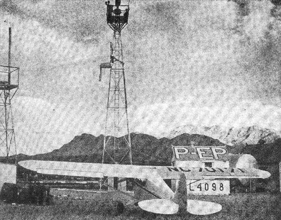 | |||||
| Piper Cub at the Rodeo Intermediate field in 1947. Used with permission. |
 | |
| Rodeo Intermediate field 2012 |
Monday
Historical Marker at the Rodeo Intermediate Field
 Building foundations at the Rodeo Intermediate Field
The Rodeo Intermediate Field is the oldest airport facility in the San Simon Valley and deserves some recognition. To that end I started the application process for a historical marker at the site. The first hurdle was getting the site listed in Geographic Names Information System. It seems that the intermediate field had never been listed. So I submitted the site with the 1936 facilities directory showing the listing for the facility. The only problem was the lat/long given in the facilities directory was incorrect and placed the intermediate field in the Chiricahua mountains. After sending in aerial photographs and screen captures from Google Earth the true location of the intermediate field was accepted and the site was listed.
Then the next step in the process was more research, drawing together all the available information on the site for submission to the New Mexico State department that oversees the placement of historical markers. A statement for the historical marker was written and submitted with the supporting research. Now the application will have to be voted on by a committee and this occurs next month. Below is the text of the application with the suggested rewrites. We'll find out the middle of next month whether they will place a marker. If so, it will be the third historical marker in the county.
Official Scenic Historic Marker Program
CPRC meeting: October 15, 2010
Name of Marker: Rodeo Intermediate Field, CAA 57A
County: Hidalgo
Review: Original Text/Replacement Marker Revised Text
Move of Existing Marker XX New Marker
NMDOT District: District 1
NMDOT Highway: near intersection of US 80 and NM 9
Existing or Proposed Text:
Developed by the U.S. Department of Commerce, the CAA intermediate field system supported early commercial aviation across the nation. The Rodeo Intermediate Field (CAA 57A) was established in 1930 to support early air traffic from the west coast and El Paso and served as an Army’s Auxiliary field during WWII.
Word Count: 50
Suggested Rewrite, tsd:
Developed by the U.S. Department of Commerce, the intermediate field system greatly increased safety in early commercial aviation. Civil Aeronautics Authority field 57A was established in 1930 to support air traffic by Standard Airlines — later TWA — from California to El Paso and served as an Army Auxiliary field during WWII. Its earthen air strips, a directional arrow pointing the way to El Paso and building foundations still are visible.
Word Count: 69
Previous Title and Text: N/A
Source(s):
http://geonames.usgs.gov/pls/gnispublic/f?p=139:3:43738547032407::NO:3:P3_FID,P3_TITLE:2507807%2CRodeo%20Intermediate%20Field%20%28historical%29
http://www.members.tripod.com/airfields_freeman/NM/Airfields_NM_SW.htm
http://wikimapia.org/15214173/Rodeo-Intermediate-Field
http://www.panoramio.com/photo/21064668
http://s890.photobucket.com/albums/ac110/BAlvarius/Tilt%20shift%20aerial%20photographs/?action=view¤t=rodeobeaconhill.jpg¤ttag=Intermediate%20field
http://wiki.worldflicks.org/rodeo_intermediate_field.html#coords=%2831.932078,-108.99238955%29&z=15
http://www.airforcebase.net/aaf/if_list.html
http://www.airfieldsdatabase.com/CAA/CAA%20R19a%20NM-WY.htm
Text Approved by CPRC on Date:
CPRC Comments:
For Referral to:
Early Aviation in the San Simon Valley
Early aviation routes frequently followed the iron compass (railroads) insuring visible landmarks all along the route. The location of the Rodeo Intermediate field with it's big red directional arrow is a good example. The San Diego (and Los Angeles) to El Paso air route followed the old El Paso and Southwestern rail line from Douglas AZ through the San Simon Valley and on to El Paso and many other intermediate fields can be found associated with railroads. So while the San Simon Valley has an established history of aviation, this history can be traced back even further than the early commercial air routes and air fields. The first transcontinental flight in US history also passed across the San Simon Valley in it's journey from Lordsburg to Wilcox on the way to the west coast.
The aircraft was a Wright Brothers modified model B biplane (known as the EX model) named after the soda Vin Fiz, Armour's newest grape soda, and was piloted by C. P. Rodgers. After 90 minutes of flight training then solo Rodgers purchased a Wright Flyer, then persuaded the Armour company to provide sponsorship. The company provided a complete support crew and and a 3 car train for the trip which would accompany Rodgers along the iron compass across the US.
The trips route (see map below) started on September 17, 1911, in New York city, then to Chicago. The route turned southwest across the heartland of the US and into Texas. A westerly course was re-established after reaching San Antonio. The route went through El Paso and into New Mexico. At one point less than 20 miles into New Mexico Rodgers spent several days stuck in the sand at the El Paso and Southwestern siding town of Mastodon (1). He used a hand car as a catapult for takeoff, crashing the hand car into an oncoming train. His route then went northwest to Lordsburg, through the San Simon Valley east to west, and then on to Wilcox. Rodgers reached the Pasadena California 49 days later. But suffered another mishap while making the hops to the coast. After 3 weeks recovery, on December 10th he landed on the beach of the Pacific Ocean completing the first trans continental flight.
References:
Back to Basics in the Vin Fiz Flyer
The Epic Flight of the Vin Fiz Flyer
The Vin Fiz - The First U.S. Transcontinental Flight
Vin Fiz Flyer

The aircraft was a Wright Brothers modified model B biplane (known as the EX model) named after the soda Vin Fiz, Armour's newest grape soda, and was piloted by C. P. Rodgers. After 90 minutes of flight training then solo Rodgers purchased a Wright Flyer, then persuaded the Armour company to provide sponsorship. The company provided a complete support crew and and a 3 car train for the trip which would accompany Rodgers along the iron compass across the US.
The trips route (see map below) started on September 17, 1911, in New York city, then to Chicago. The route turned southwest across the heartland of the US and into Texas. A westerly course was re-established after reaching San Antonio. The route went through El Paso and into New Mexico. At one point less than 20 miles into New Mexico Rodgers spent several days stuck in the sand at the El Paso and Southwestern siding town of Mastodon (1). He used a hand car as a catapult for takeoff, crashing the hand car into an oncoming train. His route then went northwest to Lordsburg, through the San Simon Valley east to west, and then on to Wilcox. Rodgers reached the Pasadena California 49 days later. But suffered another mishap while making the hops to the coast. After 3 weeks recovery, on December 10th he landed on the beach of the Pacific Ocean completing the first trans continental flight.
References:
Back to Basics in the Vin Fiz Flyer
The Epic Flight of the Vin Fiz Flyer
The Vin Fiz - The First U.S. Transcontinental Flight
Vin Fiz Flyer

Sunday
When Charles Lindbergh Came to Town (Lordsburg)
 La Marca, Jeanne. 2007. Lindbergh, Lordsburg, and Airports. Bootheel Magazine. pg 12.
The closest “city” to Rodeo is Lordsburg about 35 miles northeast (it is closer than Douglas). It is home to New Mexico’s oldest airport and was also a stop on Charles Lindbergh’s goodwill tour in 1927. On September 24th 1927, about 5 months after his Trans-Atlantic flight the Daniel Guggenheim Fund sponsored Lindbergh’s good will tour of America. Lindbergh circled the country landing in all lower 48 states and stopping at 92 cities including Lordsburg. His visit to Lordsburg was short, about half an hour but remembered.
The Lordsburg flying field was opened to aircraft on December 18th 1924 and official airport opening ceremonies were held on Labor Day 1926. Activities included an air race from Lordsburg to Hachita and back.
Thursday
A Piece of Aviation history in the San Simon Valley or When the Airlines Came to Rodeo New Mexico (kinda)
One might suppose that the somewhat isolated and remote boot heel of New Mexico would have an uncomplicated history but that is not the case. Because of its remote location transportation has played an important role in the valley’s history and development. An early map of the region shows a “coyote trail” running up the center of the valley, now replaced by Highway 80. Later came the railroad, the El Paso and Southwestern, connecting the valley to El Paso and Douglas and Bisbee. But little is known about the aviation history of the valley. Modern ranchers rely on aircraft and helicopters for many ranch operations and it is not uncommon to see a helicopter herding cattle somewhere in the valley. There are 3 registered airports in the valley and numerous airstrips on individual ranches. But what of early aviation in the valley? The first airport in the San Simon Valley was established by 1930, appearing in the early airport facilities directory. Named the Pratt Intermediate field the name was changed to the Rodeo Intermediate field in the early 1930’s. The Rodeo Intermediate field was part of the Department of Commerce’s early support system for the growing commercial aviation industry. The field, located on the west side of Antelope pass is still marked with a large red diamond and arrow pointing to El Paso and these aerial direction indicators can be found at other intermediate fields. There are 2 runways still visible, a north/south runway reported to be 3,140’ and an east/west runway 3,950’. On the southeast side of the runway intersection are several building foundations and a tank stand. Across Highway 9 is an old dump with remains of lighting, batteries, and other detritus from the airfield operations.
During World War II the airfield became part of the Army Auxiliary field system and was used by military aircraft. At some point after the war the airfield was abandoned and left for nature to reclaim.
Below is a short slideshow documenting the Rodeo Intermediate field and the southern route of Standard Airlines.
During World War II the airfield became part of the Army Auxiliary field system and was used by military aircraft. At some point after the war the airfield was abandoned and left for nature to reclaim.
Below is a short slideshow documenting the Rodeo Intermediate field and the southern route of Standard Airlines.
Subscribe to:
Posts (Atom)


 Posts
Posts