Trike flying in New Mexico. A really nice video of one pilot's view of trike flying in New Mexico. It is good to see more exposure for this unique form of aviation.
Showing posts with label New Mexico. Show all posts
Showing posts with label New Mexico. Show all posts
Monday
Integrating low level aerial photographs into Google Earth
Google Earth is great. It is used to plan many of the low level aerial photographs that are seen through out this site. The tilt down feature allows a preliminary look at the landscape and potential photographs may be planned from the comfort of the desk as opposed to flying around hoping to stumble across a photographic opportunity. But once made and posted there is little location information available to the viewer. Even when the photograph is submitted and accepted by Google Earth its location is never the exact position where the photograph was taken. In an attempt to provide more context specific information about some of the low level aerial photographs, 3 have been incorporated into Google Earth using the add a photo feature. The photograph can be precisely placed on Google Earth and then using the opacity feature collect a series of screen shots that can be animated. Below is a first pass at incorporating images into Google Earth and animating the transition from Google to photograph.
5/9/2011 Temporary Flight Resrictions, TFR
Two temporary flight restrictions are in place in the bootheel of New Mexico and nearby in Arizona. The one in New Mexico is along the border with Mexico in the Animas Valley and is in response to the Cloverdale fire. The other is near Portal Arizona and is in response to the Horseshoe fire which started yesterday. Both of these TFRs prohibit the operation of aircraft within their respective boundaries to minimize interference with fire fighting activities.
New reports on the Horseshoe fire are just starting to come out.
UPDATE 5/11/2011
The runway at Amigos del Cielo Air Park is being utilized by helicopters from the fire suppression team. Be aware that helicopters are not flying regular patterns around the runway. If landing, be alert for unexpected air traffic.
UPDATE 5/15/2011
The Cloverdale Fire TFR has been removed from the FAA's TFR website, although the TFR over the Chiricahua Mountains remains in effect.
UPDATE 5/16/2011
The TFR for the Horseshoe Two fire has been increased in size from 5 miles to 8 miles in diameter. This now covers part of the valley that lies in AZ, New Mexico is unaffected. The sectional with the TFR may be viewed here .
UPDATE 5/23/2011
The TFR for the Horseshoe 2 fire has been increased to a radius of 13 miles and now covers the whole valley around Rodeo New Mexico
New reports on the Horseshoe fire are just starting to come out.
UPDATE 5/11/2011
The runway at Amigos del Cielo Air Park is being utilized by helicopters from the fire suppression team. Be aware that helicopters are not flying regular patterns around the runway. If landing, be alert for unexpected air traffic.
UPDATE 5/15/2011
The Cloverdale Fire TFR has been removed from the FAA's TFR website, although the TFR over the Chiricahua Mountains remains in effect.
UPDATE 5/16/2011
The TFR for the Horseshoe Two fire has been increased in size from 5 miles to 8 miles in diameter. This now covers part of the valley that lies in AZ, New Mexico is unaffected. The sectional with the TFR may be viewed here .
UPDATE 5/23/2011
The TFR for the Horseshoe 2 fire has been increased to a radius of 13 miles and now covers the whole valley around Rodeo New Mexico
Wednesday
The Biggest Movie Studio in the Bootheel of New Mexico
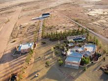
When making the aviation videos I would often joke that I ran the largest movie studio in the bootheel and it wasn’t my fault that there were no other studios down here. The landscape is expansive and the mountains create the perfect backdrop for aviation videos. The location is ideal, with 4 - 2500 square foot hangers at Amigos del Cielo airpark that doubled as sound stages and the Sky Gypsy complex as a location, it is easy to tell little stories. Now with the addition of the 80 acre Painted Pony Resort (PPR) the resources are even greater. PPR with its 3 houses, heated pool and spa, hanger and runways is located at the center of the San Simon Valley. The estate was designed with guests in mind and arriving on the property one is greeted with the view shown below. The Peloncillos as a backdrop to the main house and 2 guest houses.


Tuesday
Edge of the Playa
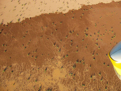
Drainages and erosion in the desert often produce unique patterns best appreciated from the air. The larger patterns are frequently found along arroyos where their intricate design is a function of water flow and soil composition, but interesting patterns also emerge around the edges of playas. The playas are the lowest areas in these enclosed drainage basins and where the dip is the shallowest. One would not expect unusual patterns where the water flow rate is the lowest but contrary to this expectation a myriad of branched patterns exist along the edge of this water filled playa. Resembling capillary beds these small drainage features can be found all around the edge of the playa and are best visualized in a water filled playa.


Click each photograph to enlarge and open in a new window.


Click each photograph to enlarge and open in a new window.
Wednesday
The Ghost Town of Old Hachita
There are at least 2 ghost towns in the bootheel and the first one is now cataloged. Old Hachita on the east side of the bootheel sits at the base of the Little Hatchet Mountains next to Turquoise Mountain. It lies just on the east side of the contential divide and all photographic flights must cross the divide to reach the site. This link contains some background information on Old Hachita
 Click on photographs to enlarge
Others have photographed Old Hachita up close, photographs of the ghost town may be found here and here and there is a 28 image Photosynth of part of the town.
Of course the fellows from emergency services made an appearence during my flight (see below) and upon returning I found Border Patrol had also visited the airport. It's good to have somebody watching your back, even if they think you are a drug smuggler.

Monday
Self Portrait or How it is done
They are worse than automobile drivers on cell phones, pilots with cameras that is.
Caught this image of my reflection in the GPS while photographing a Trinchera in the southern San Simon Valley at the mouth of Skull Canyon and it captures the ingredients required to make low level aerial photographs. The minimum prerequisites are calm air and good light. Calm conditions make all the difference when flying in confined areas or at low altitudes and good light makes all the difference in creating an interesting photograph. Then the photographic target is flown at series of decreasing altitudes looking for potential problems and obstacles (canyon walls, the ground, small hills, and power lines), all the while rechecking the winds and figuring out the best line past the target. Especially important is a flight path where I will have enough room to turn around once finished running the camera. Once this is worked out, I pick a line along the photographic target and do a low pass towards the target and begin shooting. This is repeated several times until I have something acceptable or I abort and come back another day and try again. I have photographed some sites numerous times because something was not correct, generally the winds. The goal is to bring back interesting views of the landscape and other features and not to fly into the ground.
On this particular flight I had to deal with a canyon entrance and high rock walls with a rocky hill in my flight path past the target. So just after taking the photographs I had to climb and turn to fly over the hilltop shown below.
 Self portait

Skull Canyon entrance and rocky hill on the left, shown below in detail.
 Early high test pass over rocky hill obstacle.
Caught this image of my reflection in the GPS while photographing a Trinchera in the southern San Simon Valley at the mouth of Skull Canyon and it captures the ingredients required to make low level aerial photographs. The minimum prerequisites are calm air and good light. Calm conditions make all the difference when flying in confined areas or at low altitudes and good light makes all the difference in creating an interesting photograph. Then the photographic target is flown at series of decreasing altitudes looking for potential problems and obstacles (canyon walls, the ground, small hills, and power lines), all the while rechecking the winds and figuring out the best line past the target. Especially important is a flight path where I will have enough room to turn around once finished running the camera. Once this is worked out, I pick a line along the photographic target and do a low pass towards the target and begin shooting. This is repeated several times until I have something acceptable or I abort and come back another day and try again. I have photographed some sites numerous times because something was not correct, generally the winds. The goal is to bring back interesting views of the landscape and other features and not to fly into the ground.
On this particular flight I had to deal with a canyon entrance and high rock walls with a rocky hill in my flight path past the target. So just after taking the photographs I had to climb and turn to fly over the hilltop shown below.
 Self portait
Skull Canyon entrance and rocky hill on the left, shown below in detail.
 Early high test pass over rocky hill obstacle.
Sunday
Lake Cloverdale: An Ice Age Lake in New Mexico’s Bootheel
A number of playas can be found in the valleys of southern New Mexico and Arizona and these Pleistocene lake beds are best known as migratory bird stops. In the winter these lake beds still hold water and the shallow lakes form with the winter rains attracting many species of water fowl. In the bootheel of New Mexico there are 2 lakebeds, Lake Cloverdale and the playa that runs down the center of Playas valley.
Lake Cloverdale sits at the base of Animas valley and extends into Mexico. Covering an area of about 102 km2 (27 square miles), Lake Cloverdale is now only a grassy field with scattered cattle tanks. The shoreline of this shallow pluvial lake is clearly visible in the photographs and based on the elevation change the lake was no more than 10-20 feet deep at the margin. Several stream beds from the surrounding mountains, including Cloverdale Creek were part of the lake’s recharge system as well as springs like Cienega Springs which brought ground water into the lake. It now sits abandoned by the water as the climate dried after the last ice age and is now the largest grass landing field I can think of, although it sits on the 320,000 acre Diamond A Ranch (still known locally as the Grey Ranch).
Click to enlarge photographs

Looking south down Animas valley along the drainage toward Lake Cloverdale.

Looking southwest from the north shore of Lake Cloverdale across the former lake.

View from the south looking north at the former shoreline of Lake Cloverdale.

Looking north at the shoreline, showing the boat ramp on Lake Cloverdale.
Lake Cloverdale sits at the base of Animas valley and extends into Mexico. Covering an area of about 102 km2 (27 square miles), Lake Cloverdale is now only a grassy field with scattered cattle tanks. The shoreline of this shallow pluvial lake is clearly visible in the photographs and based on the elevation change the lake was no more than 10-20 feet deep at the margin. Several stream beds from the surrounding mountains, including Cloverdale Creek were part of the lake’s recharge system as well as springs like Cienega Springs which brought ground water into the lake. It now sits abandoned by the water as the climate dried after the last ice age and is now the largest grass landing field I can think of, although it sits on the 320,000 acre Diamond A Ranch (still known locally as the Grey Ranch).
Click to enlarge photographs

Looking south down Animas valley along the drainage toward Lake Cloverdale.

Looking southwest from the north shore of Lake Cloverdale across the former lake.

View from the south looking north at the former shoreline of Lake Cloverdale.

Looking north at the shoreline, showing the boat ramp on Lake Cloverdale.
Thursday
Selected Aerotrekking Images from the Sky Gypsies
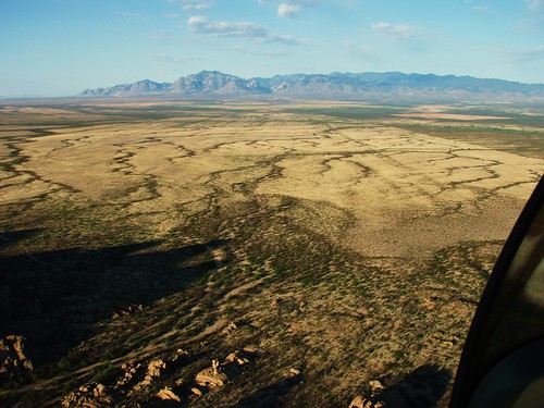
This was taken while exiting a small canyon on north of Highway 80 at Granite Gap about 10 miles south of I-10 in New Mexico. The spreading dark serpentine drainage's contrast with the light grasses, while across the valley in the background stands Portal Peak (8000') and the entrance to Cave Creek Canyon on the east side of the Chiricahua Mountains in southern Arizona.
Monday
Advantages of Being Seen as a Threat by the Border Patrol or Having a Personal Emergency Service
With the perceived increase in smuggler traffic, especially those crossing the border in light sport aircraft, flying around the Boot Heel of New Mexico can get pretty interesting at times. One of the side effects of this increase in aerial traffic is the Border Patrol’s increased awareness. Border Patrol visits are a regular occurrence at the Sky Gypsy Complex when someone is up flying. The visiting agents are generally unknowledgeable about the aircraft, its capabilities, or requirements and require some briefing before they begin to understand. What is unfortunate for them is that they get calls about us on a regular basis and an agent is dispatched to drive down from Lordsburg or up from Douglas and then around the Boot Heel looking for us. While some pilots may bristle at the idea of the Border Patrol watching them fly, there is a different way to view the situation. If I were to experience an engine failure or have some other problem that required landing out some place I can be assured that assistance will arrive promptly where ever I land, and this is a good thing. With 1200 square miles of big empty open E class airspace over the high desert, landing out in some remote area is always a possibility. But with the Border Patrol following us around watching us fly we have a built-in safety net. While I’m out Aerotrekking or taking pictures and filming in some remote area I can be assured that the Border Patrol has my back.
Subscribe to:
Posts (Atom)


 Posts
Posts