Showing posts with label Rodeo New Mexico. Show all posts

Wednesday

Rodeo Intermediate Field, the First Airport in the San Simon Valley

Note:  This first appeared in Blogging from the Boot Heel

An ongoing project for the past several years was the documentation and submission of the Rodeo Intermediate Field as a site worthy of a New Mexico historical marker.  It began with the discovery of the site while flying one afternoon several years ago.  Long straight lines in the desert and a big red arrow pointing east toward El Paso stood out on the desert at the mouth of Antelope pass along Highway 9.  Exploring further on foot, building foundations and runways became apparent.  Inquiries to local residents produced no concrete information and many were unaware of the sites existence.  Information about the site required a longer memory and after consulting author and the local historian Jr. Gomez and explanation arrived, an old airport.  The local memories only went back to WWII when the site was an Army Air Force Auxiliary field with lighted runways visible in Portal, but further research turned up a longer history which extended back to the late 1920's.  Developed by the Department of Commerce and known for a year as the Pratt Intermediate Field, the name was changed to the Rodeo Intermediate Field.  The site was developed in support of early commercial aviation along a route from California east.  Early commercial aviation, both transport and mail relied on the iron compass as a navigational aid and the El Paso and Southwestern Railroad running from Douglas to El Paso was an ideal navigational aid along a southern route.  Other intermediate field routes were established across the U.S. and in New Mexico an early route also extended across the northern part of the state through Albuquerque.

Standard Airlines, a subsidiary of Aero Corp and later to become TWA, began flights from California to El Paso on Feburary 5, 1929 as an Air-Rail line where passengers would fly part of the route then continue by train east from El Paso.  In support of this commercial activity the Department of Commerce had been locating a series of "intermediate fields" along these air routes.  Located 40-50 miles apart these intermediate fields provided a measure of safety for early commercial airlines in cases of mechanical or weather related problems.  Along the southern routes air traffic converged on Phoenix and Tucson then proceeded via Douglas around the Chiricahua mountains and up the San Simon Valley to Antelope pass where air traffic would again turn east following the rail line to the "planeport" in El Paso, see the video for air traffic maps.  Passing the Rodeo Intermediate Field early air traffic then continued through intermediate fields located in Hachita, Columbus, and Mt. Riley before arriving in El Paso.

From an intermediate field to an Army Air Force auxiliary field the Rodeo Intermediate Field slowly grew.  More buildings were constructed including a supply depot and radio building which after relocation into Rodeo became Rodeo Cottages.  But after the end of WWII the need for auxiliary fields disappeared.  Although still in use after the war, see this photograph, the Rodeo Intermediate Field began it's return to nature.  As it sits today the Rodeo Intermediate Field lies on BLM land on the east side of the San Simon Riverbed north of Highway 9.  The site is marked by a concrete tank stand and building foundations as well as a runway may be seen from the road, while the historical marker is located at the intersection of Highway 80 and Highway 9, 2.25 miles to the west.


A short slideshow of Standard Airlines and the Rodeo Intermediate Field

Rodeo Intermediate Field historical marker

Points of Interest 
The new historical marker was submitted to the "Historical Marker Data Base" for inclusion. The marker will also be included in the next edition of "Roadside New Mexico:  A Guide to Historic Markers".

Rodeo Intermediate Field

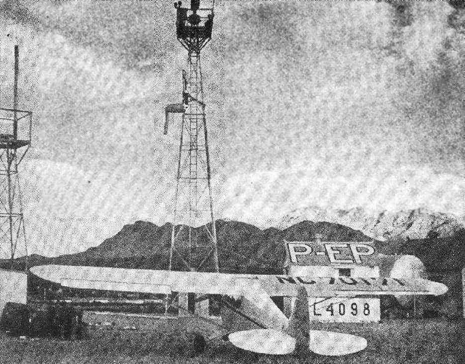
A photograph of the Rodeo Intermediate Field from 1947 surfaced and was posted on Abandoned and Little-Known Airfields: Southwestern New Mexico.  Originally appearing in the June 1947 issue of Skyways Magazine the image is of a new Piper Cub, on a ferry flight to California, parked in front of the radio tower at the Rodeo Intermediate field and the image shows the Peloncillo Mountains south of Highway 9 in the background.  This view of the mountains in combination with concrete foundations and footings, especially the fuel tank stand which is still in existence, on the site allows the original location of the photograph to be relocated.  This was done and the view reproduced 65 years later.  Both views can be compared to one another and it is clear that although the towers and buildings are gone the view remains the same.  As a side note, still awaiting the installation of the new historical marker by the state at the site.

Piper Cub at the Rodeo Intermediate field in 1947.  Used with permission.    
Rodeo Intermediate field 2012

Tuesday

Photograph of the Dirt

Below is a finished photograph of another erosion feature from the San Simon Valley.  Erosion of denuded landscape produces fractal like patterns which can only be appreciated from the air and is just one of the many uses of a weight shift control light sport aircraft.

The landscape takes on a completely different character from just a few feet above the ground and flying at low levels across open countryside is one way to appreciate the beauty.  Here is a link to a truly spectacular video of low level aviation from Washington State.  Entitled One October Evening this video demonstrates the beauty of low level aviation in a weight shift control light sport aircraft.

Erosion features in the San Simon Valley near Rodeo New Mexico

Wednesday

Another Updated TFR

The temporary flight restrictions in place over the Chiricahua Mountains have been expanded again. Below is a Google Earth Screen capture showing the outline of the new TFR which extends from the surface to 12,000' MSL.  The latest information on flight restrictions may be found here.  An aircraft violated the TFR the other week and landed at Amigos del Cielo air park which is being used as a helibase by the firefighters.

Newest TRF includes the Painted Pony Resort

Friday

Rodeo Intermediate Field Historical Marker Approved

The application for a historical marker at the site of Rodeo New Mexico's first airport, the Rodeo Intermediate Field, has been approved by the New Mexico Scenic Historic Marker by the Cultural Properties Review Committee at its December 10 meeting.  Because of budgetary constraints the marker will not be placed until sometime this summer.  But it is good news, the first airport in the San Simon Valley and part of the national intermediate field system will be recognized for its historic value.

Wednesday

Winds Aloft

The area is due for some cold temperatures and wind.  The winds aloft are currently picking up and it is settling into the valley, there is also a high wind warning in effect.  This has resulted in some unusual cloud formations over the Chiricahua Mountains, including mountain waves.  Below are 2 photographs of one unusual cloud formation taken coming back from the bungalow.  The colors were inverted and contrast increased to highlight the small wisps.  The varying texture of the clouds gives the appearance of motion to the photograph, almost as waves crashing on a beach.  While the second photograph are of mountain waves over the Chiricahuas. No flying for a couple of days.

Winds Aloft

Mountain Waves

Thursday

Rodeo, New Mexico

Finished a couple of articles for Wikipedia on Rodeo and the bootheel. Have been working on rewrites for the article on the Chiricahua Mountains and added pictures to several other articles. All great places to fly down here which deserve more attention. The goal of this work is to get all the online information about Rodeo and it's environs "out there" and demonstrate activity, that is showcase what is going on down here.

Also finished creating a new blog for the Painted Pony Resort called "Blogging from the Boot Heel" to cover non aviation activities .

Friday

Civil Aeronautics Authority field 57A, Rodeo Intermediate field

The Rodeo Intermediate field (Civil Aeronautics Authority field 57A) was the first airfield in the San Simon Valley. Built by the Department of Commerce it served as a turn point on the route from California to El Paso. The field was used as an auxiliary field during WWII and was eventually shut down in the early 1950's. The buildings from the site were not torn down but moved. The radio building now sits in the town of Rodeo, New Mexico's most western town and is part of Rodeo Cottages. Below are photographs of the roof of the old radio building where the air route designation can still be read. On the back roof it reads "SD-EP 26A" and underneath the other designation 57A can still be seen.


Front roof of Rodeo Cottages showing "Rodeo"

Back roof of Rodeo Cottages showing "SD-EP 26A"

Sunday

Sixty Five Years ago Yesterday

August 21, 1945, a Grumman Hellcat F6F and a B-25 managed to intersect in the skies 5 miles north of Rodeo. The mid-air collision sent the Hellcat to the ground but the B-25 managed to make it to Douglas and land. Don't know where the specific crash site is located but it should be somewhere around Amigos del Cielo airpark. The details can be found here.

A total of 8 aircraft accidents are reported from Rodeo New Mexico in the Air Force accident database during WWII.

Monday

Low Level Clouds

The image below is a multi-image panorama spanning 13 miles of the Chiricahua Mountains at sunset. Taken from the ground since the monsoons are here and the runway is wet. Note the low level cloud band running the length of the mountain range a few hundred feet off the ground. Calm still air would make for great flying.


Click image to see a larger view.

Wednesday

Photosynth Point Cloud of Paramore Crater

Microsoft's Photosynth has an interesting feature that is particularly applicable to aerial photosynths. Below is the point cloud from Flying below ground level that I created by circling up and out of the crater while photographing the interior. The data points create a nice 3D rendering of the crater which can be viewed by clicking on the second button from the right and choosing "overhead". This will bring up a complete view of the crater based on the point cloud.


Thursday

Life in the Bubble or Living on Rodeo Time

Many have suggested that everything moves slowly in Rodeo and projects never seem to be completed within the allotted time span. Like the Deep South before air conditioning when life was lived at a much slower pace it lead to the belief that southerners were genetically predisposed to laziness and sloth, but here in the valley this belief manifests itself in frustration, anger, and recriminations generally resulting in misunderstandings and hurt feelings. There is an alternative explanation for these observations that does not require blaming individuals and several indirect lines of evidence support the notion that time is actually slowed in the area around Rodeo and Portal.

The idea is that this area of the San Simon Valley exists in a bubble which is moving at close to the speed of light relative to the rest of the planet. By traveling at close to the speed of light time would slow inside the bubble. If true it would not only explain why things appear to take forever but would be an empirical validation of Einstein’s theory of relativity.

I’m not suggesting that the San Simon Valley is visibly physically moving nor am I suggesting the bubble itself is visible. No, just the effects of moving at close to the speed of light can be detected in the way things work here.

But what lines of evidence are consistent with this notion?

1. By September last year, 5 residents of Portal had turned 90.
2. There are a high number of academics with PhDs in the area. With no University the question becomes why would they congregate here in the middle of nowhere?
3. There are a number of Astronomers and telescope facilities in the valley, again out in the middle of nowhere.
4. Mail service is slow and inconsistent.

The number of people who are advanced in years is disproportionate to the areas low population density. Portal has few residents and consists only of a café/motel and a post office.

The high number of academics could be the result of some ones discovery of the slow time bubble at some point in the past. Of course they would share the information with their friends who would also want to take advantage of longer life spans by moving to the bubble. The end result would be a high number of academics in the bubble all enjoying long life spans.

The number of Astronomers and observatories while consistent with the dark skies found here, it is also consistent with the explanation given above.

It has been noted that priority mail from the bubble takes several days longer to reach its destination then when mailed from Lordsburg or Douglas (which are outside the bubble). Just the time a letter spends sitting in the post office before moving out results in days passing outside of the bubble where time is moving faster, the end result being late mail.

This notion also has the added benefit of explaining why some people are concerned about the light sport aircraft and aviation activities in the valley. Their concerns must stem from a fear of the aircraft poking holes in the bubble and letting out the slow time which would adversely affect their life span. But since it is possible to cross the boundary in cars without creating permanent damage to the bubble, aircraft do not pose a threat to the slow time found here.

This has been an exercise in circular reasoning which can also be found here in the valley and seems to be a specialty of student pilots.

Saturday

Registered Airports of Rodeo New Mexico

There are 3 registered airports south of I-10 in the 320 square miles of the San Simon Valley and all are located near Rodeo.

The Rodeo airport is operated by Rick and Cleo Chamberlain the owners of Chamberlain Aviation who are both CFIs and Rick is an A&P mechanic. They cater to mostly fixed wing traffic but many weight shift students use the Rodeo Airport as a way point on their cross country.

Mystery Well Ranch is a private strip on the sectionals.


Finally, Amigos del Cielo, home of the Sky Gypsies is an airpark dedicated to light sport aircraft.

Friday

Flight to the Playa

Above, Looking West towards Animas New Mexico
Below, Student on Cross Country, Headed South

Flew east past Animas New Mexcio and over to the Playa yesterday morning to take video and still photographs. A student was also on their cross country and I found them in Playas Valley. I captured several photographs of the student in transit but only 1 was acceptable, above. The other photographs from the flight are in the sidebar aerial pictures or just go straight to the photograph hosting site.

After I had returned and finished my post flight, a border patrol agent drove up. I had seen him on my way back from the playa driving along highway 9. Apparently someone had called the Lordsburg office to say there was a light aircraft flying east and he had been dispatched to drive around the countryside looking for me or the student, he finally found me. Apparently there had been another incursion up Animas Valley from Mexico the previous night, so he was sent out to see if this were part of that event. I gave the usual indoctrination spiel about registered aircraft, pilot’s license, CFIs, DPEs, student training, and recreational aviation. Then invited him and his coworkers to come out and take an introductory lesson. Well, we had a nice chat and he departed with a little more information about weight shift control light sport aircraft. At some point they will pop for the introductory lesson and then we can show them how training and experience results in competent pilots.

As I noted in the previous post Smugglers in Trikes weight shift control aircraft are being used to smuggle drugs into the US. Photographs of the recovered aircraft show pretty rickety aircraft which did not look airworthy, missing nose cones and home made front forks, overall pretty scary looking aircraft. It is surprising they made it as far as they did.

Monday

Pronghorn Antelope (Antilocapra Americana) - Species of the Day


Below is a single male (top) with the characteristic black cheek pouches and 2 females. Photographed east of the mouth of Horseshoe canyon, Chiricahua Mountains, on the east side of Highway 80.


The pronghorn antelope (Antilocapra Americana) is found throughout the
western United States
. In the San Simon and San Bernadino Valleys straddling the Arizona New Mexico border Pronghorn can be found in the open grasslands. The only species in the family Antilocapridae, pronghorns have characteristic branched keratinized horns which are shed yearly leaving only the bony core. An individuals range will cover 20-40 square miles but they will congregate into herds. Males will collect harems of 3-8 females prior to mating. Generally one or two fawns are produced in the in late spring or early summer. Pronghorn can be found in the vicinity of Rodeo at the base of the Peloncillo Mountains.

Saturday

Geology of Granite Gap, Peloncillo Mountains

Above. A view looking west along Highway 80 bisecting the Peloncillo Mountains at Granite Gap. The entrance to Cave Creek Canyon can be seen on the right side of the photograph in the Chiricahua Mountains in the background.
Below. A view off the wingtip looking north from Highway 80 to Granite Peak which rises 1500' above the floor of the valley.


The intrusive granite in Granite Gap occupies approximately 1.5 square miles consisting of an east/west oriented upfaulted block. It is bounded by steeply dipping faults on the north and south but sinks beneath the valley aluvium on the east and west. It is presumably precambrian and is overlain by cambrian Bolsa quartzite. The granite has intruded into younger Mississippian aged sedimentary rocks and along the margins where numerous small mining operations removed copper, lead, zinc, silver, and tungsten.

References

Gillerman, E. Bulletin 57, Geology of the Peloncillo Mountains, Hidalgo Dounty, New Mexico and Cochise County, Arizona. 1958. State Bureau of mines and mineral resources New Mexico Institute of Mining & Technology . Socorro, New Mexico pp 152.

Thursday

A Piece of Aviation history in the San Simon Valley or When the Airlines Came to Rodeo New Mexico (kinda)

One might suppose that the somewhat isolated and remote boot heel of New Mexico would have an uncomplicated history but that is not the case. Because of its remote location transportation has played an important role in the valley’s history and development. An early map of the region shows a “coyote trail” running up the center of the valley, now replaced by Highway 80. Later came the railroad, the El Paso and Southwestern, connecting the valley to El Paso and Douglas and Bisbee. But little is known about the aviation history of the valley. Modern ranchers rely on aircraft and helicopters for many ranch operations and it is not uncommon to see a helicopter herding cattle somewhere in the valley. There are 3 registered airports in the valley and numerous airstrips on individual ranches. But what of early aviation in the valley? The first airport in the San Simon Valley was established by 1930, appearing in the early airport facilities directory. Named the Pratt Intermediate field the name was changed to the Rodeo Intermediate field in the early 1930’s. The Rodeo Intermediate field was part of the Department of Commerce’s early support system for the growing commercial aviation industry. The field, located on the west side of Antelope pass is still marked with a large red diamond and arrow pointing to El Paso and these aerial direction indicators can be found at other intermediate fields. There are 2 runways still visible, a north/south runway reported to be 3,140’ and an east/west runway 3,950’. On the southeast side of the runway intersection are several building foundations and a tank stand. Across Highway 9 is an old dump with remains of lighting, batteries, and other detritus from the airfield operations.

During World War II the airfield became part of the Army Auxiliary field system and was used by military aircraft. At some point after the war the airfield was abandoned and left for nature to reclaim.


Below is a short slideshow documenting the Rodeo Intermediate field and the southern route of Standard Airlines.