Until now the closest thing to flying like a bird was either hang gliding or open cockpit weight shift control aircraft. But now someone has solved the problems with one of the earliest designs for flying, flapping wings. A Dutch engineer has created a pair of bird wings for humans and video of his first flight is shown below. It appears there is some interesting gearing and motor assists and I would imagine some electronic control system, all the details are on his blog.
The general consensus developing is the video is a fake and I would have to agree. The give away is the pilots legs. At first they hang down, unsupported, but slowly rise and the pilot is stretched out. While early hang gliding harnesses suspended the pilot there were mechanisms for holding the legs extended. See this video for a comparison.
Update: The video maker admitted the hoax, an article on Wired Science has all the details.
Showing posts with label aviation. Show all posts
Showing posts with label aviation. Show all posts
Wednesday
Saturday
A Different Kind of Aerial Photography: Low Level Images From Weight Shift Control Aircraft
Creating meaningful images takes time, patience, and skill, and the submitted results visible on the various photograph hosting sites like Flickr attest to the creativity of photographers all over the planet. But as human beings we are limited to the creating photographs within about 6 feet of the ground and generally within walking distance of our car and this is reflected in the type and distribution of photographs in appearing in Google Earth and on other maps. Generally, the more energy required to capture an image the less likely someone will create the it and share it. People push the boundaries by driving till the road ends then hiking up mountains, standing on cliff edges, or hanging off ropes, all in an effort to capture a unique image but there are additional limitations in photographing many areas of the country, primarily access. Land ownership prevents many from going where photographic opportunities exist. Landowners, especially in the west, jealously guard access to their property even if the photographer is only crossing to access public lands. But while the land maybe owned by an individual, the airspace is not. Rather it is regulated by the Federal Government and belongs to no individual and best of all it starts just above the dirt. A number of photographers use the freedom of the skies to capture images from the air and have produced some beautiful photographs.
All kinds of aerial platforms are used to capture images from kites and balloons, to helicopters and fixed wing general aviation aircraft but the generated images all share one thing in common, they are views looking down. They exploit the advantage of height to capture a larger panorama or a perspective not visible from the ground. I have made plenty of these types of images and the advantage of elevation certainly provides a unique perspective. But why are these images made, what is the goal of the image? Is it Art or is the goal descriptive, to relate to the viewer what the photographer sees from their vantage point in the aircraft? As Art the emotional response the image provokes is important and dictates the view. As a descriptive tool aerial photographs are just that views from “on high”. I have taken a different approach with many of my aerial photographs. Instead of Art or a pure descriptive approach I have been creating aerial photographs taken from places difficult to access. The goal is to create an image that could have been taken from the ground but was not.
Using open cockpit weight shift control aircraft light sport aircraft, affectionately known as trikes, a photographer can place the camera anywhere from 6 feet up. In addition a photographer can place the camera view on any spot not easily accessible to the ground based photographer creating either landscape photographs or up close shots of specific subjects without trespassing and becoming the immediate recipient of a landowners wrath. In other words low level aerial photography at the interface between the ground and sky. For example, the photograph of Animas New Mexico shown below was taken near the top of a local hill on private land. Instead of tracking down the landowners and gaining access through locked gates then climbing the hill, the aircraft was flown at hilltop height passing a wing over the hill top to capture the photograph.
Compare the Google Earth view with the photographed image. The Google Earth image is shown higher and somewhat back to show the top of the hill used as the geographic location for the photograph. The rotated satellite image from the hill top is the same as the captured photographic image.

Image courtesy of Google Earth.

Or this view of Granite Mountain north of Granite Gap New Mexico. The view is horizontal as though taken from atop one of the rock outcroppings but was taken above the terrain from the aircraft.
Images taken in this manner will have the characteristic horizontal or upward and are indistinguishable from a photograph taken from the ground but provides more information and is pleasing. In addition to the ground based perspective all the images created are designed to be viewed on the computer screen and not printed. With so many professional photographers producing creative content there is no expectation that any of the images will ever be printed. So I strive to make the images that view well in a small format on the computer screen. As such the photographs are viewed on several different computer screens and only those chosen which provide the viewer with the best overall effect.
All kinds of aerial platforms are used to capture images from kites and balloons, to helicopters and fixed wing general aviation aircraft but the generated images all share one thing in common, they are views looking down. They exploit the advantage of height to capture a larger panorama or a perspective not visible from the ground. I have made plenty of these types of images and the advantage of elevation certainly provides a unique perspective. But why are these images made, what is the goal of the image? Is it Art or is the goal descriptive, to relate to the viewer what the photographer sees from their vantage point in the aircraft? As Art the emotional response the image provokes is important and dictates the view. As a descriptive tool aerial photographs are just that views from “on high”. I have taken a different approach with many of my aerial photographs. Instead of Art or a pure descriptive approach I have been creating aerial photographs taken from places difficult to access. The goal is to create an image that could have been taken from the ground but was not.
Using open cockpit weight shift control aircraft light sport aircraft, affectionately known as trikes, a photographer can place the camera anywhere from 6 feet up. In addition a photographer can place the camera view on any spot not easily accessible to the ground based photographer creating either landscape photographs or up close shots of specific subjects without trespassing and becoming the immediate recipient of a landowners wrath. In other words low level aerial photography at the interface between the ground and sky. For example, the photograph of Animas New Mexico shown below was taken near the top of a local hill on private land. Instead of tracking down the landowners and gaining access through locked gates then climbing the hill, the aircraft was flown at hilltop height passing a wing over the hill top to capture the photograph.
Compare the Google Earth view with the photographed image. The Google Earth image is shown higher and somewhat back to show the top of the hill used as the geographic location for the photograph. The rotated satellite image from the hill top is the same as the captured photographic image.

Image courtesy of Google Earth.
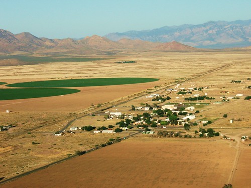
Or this view of Granite Mountain north of Granite Gap New Mexico. The view is horizontal as though taken from atop one of the rock outcroppings but was taken above the terrain from the aircraft.
Images taken in this manner will have the characteristic horizontal or upward and are indistinguishable from a photograph taken from the ground but provides more information and is pleasing. In addition to the ground based perspective all the images created are designed to be viewed on the computer screen and not printed. With so many professional photographers producing creative content there is no expectation that any of the images will ever be printed. So I strive to make the images that view well in a small format on the computer screen. As such the photographs are viewed on several different computer screens and only those chosen which provide the viewer with the best overall effect.
Trouble With The Neighbors
Neighbors giving you problems, nowhere to turn? Mount a canon on your trike or flex wing microlight. Part way down this page of WWI aviation photographs is one of a cannon mounted in place of the engine on an aircraft.
I suspect the recoil from firing might induce some pitch stability problems though.
Ohh and don’t forget to update your weight and balance form after you finish mounting your canon. I don’t know whether this is considered a major modification by the FAA. Will have to get some advice on that.
Hat tip The Vintage Aviator via Trike Pilot Social
I suspect the recoil from firing might induce some pitch stability problems though.
Ohh and don’t forget to update your weight and balance form after you finish mounting your canon. I don’t know whether this is considered a major modification by the FAA. Will have to get some advice on that.
Hat tip The Vintage Aviator via Trike Pilot Social
Sunday
The History of Sky Gypsies
According to the unencyclopedia flying gypsies (flypsies) or Sky Gypsies have been around since the middle ages. These flying vagabonds used homemade aircraft primarily as a means to escape angry locals or police. This is in contrast to many of today’s Sky Gypsies whose love of aviation exceeds their income. They are easily recognized by their poor dress, shaggy hair, and emaciated look but somehow manage to own at least one aircraft. While the airworthiness of their aircraft may be questioned modern Sky Gypsies are always ready to fly.
Subscribe to:
Posts (Atom)


 Posts
Posts