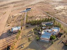
An ongoing project for the past several years was the documentation and submission of the Rodeo Intermediate Field as a site worthy of a New Mexico historical marker. It began with the discovery of the site while flying one afternoon several years ago. Long straight lines in the desert and a big red arrow pointing east toward El Paso stood out on the desert at the mouth of Antelope pass along Highway 9. Exploring further on foot, building foundations and runways became apparent. Inquiries to local residents produced no concrete information and many were unaware of the sites existence. Information about the site required a longer memory and after consulting author and the local historian Jr. Gomez and explanation arrived, an old airport. The local memories only went back to WWII when the site was an Army Air Force Auxiliary field with lighted runways visible in Portal, but further research turned up a longer history which extended back to the late 1920's. Developed by the Department of Commerce and known for a year as the Pratt Intermediate Field, the name was changed to the Rodeo Intermediate Field. The site was developed in support of early commercial aviation along a route from California east. Early commercial aviation, both transport and mail relied on the iron compass as a navigational aid and the El Paso and Southwestern Railroad running from Douglas to El Paso was an ideal navigational aid along a southern route. Other intermediate field routes were established across the U.S. and in New Mexico an early route also extended across the northern part of the state through Albuquerque.
Standard Airlines, a subsidiary of Aero Corp and later to become TWA, began flights from California to El Paso on Feburary 5, 1929 as an Air-Rail line where passengers would fly part of the route then continue by train east from El Paso. In support of this commercial activity the Department of Commerce had been locating a series of "intermediate fields" along these air routes. Located 40-50 miles apart these intermediate fields provided a measure of safety for early commercial airlines in cases of mechanical or weather related problems. Along the southern routes air traffic converged on Phoenix and Tucson then proceeded via Douglas around the Chiricahua mountains and up the San Simon Valley to Antelope pass where air traffic would again turn east following the rail line to the "planeport" in El Paso, see the video for air traffic maps. Passing the Rodeo Intermediate Field early air traffic then continued through intermediate fields located in Hachita, Columbus, and Mt. Riley before arriving in El Paso.
From an intermediate field to an Army Air Force auxiliary field the Rodeo Intermediate Field slowly grew. More buildings were constructed including a supply depot and radio building which after relocation into Rodeo became Rodeo Cottages. But after the end of WWII the need for auxiliary fields disappeared. Although still in use after the war, see this photograph, the Rodeo Intermediate Field began it's return to nature. As it sits today the Rodeo Intermediate Field lies on BLM land on the east side of the San Simon Riverbed north of Highway 9. The site is marked by a concrete tank stand and building foundations as well as a runway may be seen from the road, while the historical marker is located at the intersection of Highway 80 and Highway 9, 2.25 miles to the west.
A short slideshow of Standard Airlines and the Rodeo Intermediate Field
| Rodeo Intermediate Field historical marker |
| Points of Interest |


This is a great Historic marker for the area, Thank you so much for putting all your effort into getting this done!
ReplyDeleteThis is a great blog I really enjoyed reading it.
Thanks DiAnn. Now on to the next project.
ReplyDeleteBest casino site | luckyclub.live
ReplyDeleteRead our review of the UK's top online luckyclub casino site. Play over 550 slot, video poker, and other games online today from leading providers. Rating: 4.7 · 100 votes