Tuesday

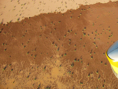
Edge of the Playa

Drainages and erosion in the desert often produce unique patterns best appreciated from the air. The larger patterns are frequently found along arroyos where their intricate design is a function of water flow and soil composition, but interesting patterns also emerge around the edges of playas. The playas are the lowest areas in these enclosed drainage basins and where the dip is the shallowest. One would not expect unusual patterns where the water flow rate is the lowest but contrary to this expectation a myriad of branched patterns exist along the edge of this water filled playa. Resembling capillary beds these small drainage features can be found all around the edge of the playa and are best visualized in a water filled playa.


Click each photograph to enlarge and open in a new window.

Wednesday

Canyon Running in the Philippines

Below is a video shot in Bukidnon. Carlito Frias shot this video from a weight shift control aircraft in the steep canyons of this province in the Philippines. It captures the beauty of these deeply eroded canyons as well as the surrounding countryside.

THE GREEN CANYONS OF BUKIDNON from Carlito frias on Vimeo.

Sunday

The Monsoons are Over

The monsoons season was late this year. It traditionally begins on July 4th but this year was late. There were periods of rain and the playas of the bootheel filled. Below is a low level aerial photograph of the playa in Playas Valley filled with monsoon runoff.


Click to enlarge

Monday

Transition

We've moved! Kinda.
The Sky Gypsies blog will now be created 1 mile east (as the WSC aircraft flies and 3 miles by road) from it's former location at the Sky Gypsies complex in Amigos del Cielo Airpark 5 miles north of Rodeo New Mexico. The posts, aerial photography, artwork, and videos will now be produced at the Painted Pony Resort just east of the airpark. Operating out of a 2200 ft airstrip on the 80 acre resort, the Sky Gypsies blog will continue to create funny videos and bring unique aerial views of the high desert landscape from New Mexico's bootheel.


Click photo to enlarge

Saturday

Bootheel Photodocumentation Project in Google Earth: Recent Submissions

As mentioned in earlier posts, a number of the low level aerial photographs taken from weight shift control aircraft have been submitted to Google Earth for inclusion on the map. Below is an interactive Google Earth map with many of the photographs from the project.